.jpg)


It’s important that all residents understand their flood risk and have a plan for what you would do in a flood.
Never walk, ride or drive through floodwaters.
In a life-threatening situation, call 000 (triple zero).
For assistance during an emergency such as flood, storm, or tsunami, please contact the NSW State Emergency Service (SES) on 132 500 or visit the SES website.
SES provides advice on how to manage your flood risk at https://www.ses.nsw.gov.au/flood-awareness-nsw/
For helpful tips and information, please visit our webpage Be prepared for a flood | City of Parramatta
Visit NSW Fire and Rescue and NSW State Emergency Services’ Hazards Near Me webpage for maps with live updates, information, and tips on planning for emergencies.
You can also download the Hazards Near Me app for your phone.
The information you provide will be used to improve our understanding of flood risk. Personal contact details will not be shared outside of this project.
If you leave your contact details, we will reply to everyone who has made a submission to say how we dealt with your feedback. Please note, participating in this flood study does not mean your property is flood-affected.
The flood study does not require Council to visit your property. You will only be contacted by Council if you have made a booking with our team or have contacted us with a question.
The NSW Government requires all Councils to manage the risk of flooding within their Local Government Area. More details about these requirements can be found here.
Collecting information is the first step in understanding local flood risk.
A flood study is a technical investigation of flood behaviour from small floods up to the largest possible flood. Flood modelling techniques have been updated, and new technologies provide more accurate information on the hydraulic flood conditions within the catchment area.
Flood studies now not only look at the current flood risk from creeks and rivers, but also from other sources including stormwater drains.
Studies model current risks and future flood risks, including those that may result from climate change. City of Parramatta Council will use the information it gathers from public exhibition of the Draft A’Becketts Creek Flood Study to create final flood models.
The A’Becketts Creek Flood Study, once finalised and officially adopted by City of Parramatta Council, will be capable of predicting water movement in various sizes of flood, from smaller rainfall events up to the biggest flood that could ever occur – a ‘Probable Maximum Flood’ (PMF)* level. It will be available to NSW Government agencies and anyone who needs information about flooding in the A’Becketts Creek catchment area.
*The Probable Maximum Flood (PMF) combines a range of extreme conditions and probabilities to calculate the largest flood that could possibly occur within a catchment. PMF events are rare, but a PMF is calculated to understand the full risk of flooding.
In flood modelling and flood studies, various sized events are referred to by specific terms.
What is a 1% AEP flood event?
A 1% AEP (Annual Exceedance Probability) is a flood event of a size that has a 1% chance of occurring at a particular location in any given year.
This used to be known as a ‘1-in-100-year’ flood, a term which can be misleading. Some parts of Australia have experienced several ‘1-in-100-year’ floods in 10 years or less.
What is the Probable Maximum Flood (PMF)?
The Probable Maximum Flood (PMF) combines a range of extreme conditions and probabilities to calculate the largest flood that could possibly occur within a catchment.
PMF events are rare, but a PMF is calculated to understand the full risk of flooding. The PMF is also used in the design of critical and sensitive facilities such as hospitals, childcare centres, nursing homes, schools, and emergency service facilities.
What is a Flood Planning Area (FPA)?
A Flood Planning Area (FPA), is a term that refers to areas where new developments are likely to be subject to flood-related planning controls that are designed to minimise flood risks.
Details of the process used to develop the FPA is provided in the Draft Flood Study Report.
The preliminary FPA has been determined as part of the draft flood study. This will be finalised in the next stages of the Flood Risk Management process.
What is a Flood Planning Level (FPL)?
Once a flood study is finalised, one type of information it provides is the Flood Planning Level. The Flood Planning Level considers the depth of flooding which may happen in a ‘standard’ flood. For this flood study, the ‘standard’ flood has been defined according to NSW Government guidance and consists of allowances for:
- 1% AEP flood level
- Freeboard (allowance for modelling and environmental uncertainties)
- Climate change.
The Flood Planning Level is then used to define the extent of the Flood Planning Area*.
*A 1% AEP (Annual Exceedance Probability) is a flood event of a size that has a 1% chance of occurring at a particular location in any given year. This used to be known as a ‘1-in-100-year’ flood, a term which can be misleading. Some parts of Australia have experienced several ‘1-in-100-year’ floods in 10 years or less.
*A Flood Planning Area refers to areas where new developments are likely to be subject to flood-related planning controls to minimise flood risks.
Large floods are, fortunately, very rare, and might occur only once or twice every few decades. You may never have personally experienced flooding. However, when a big flood does happen, it can cause a lot of damage to property and be a risk for people exposed to the flood.
In Parramatta, big floods happened in 1986 and 1988, and a smaller flood took place in 2015. However, any flooding event can cause significant damage and disruption.
Flooding is the second most deadly natural hazard in Australia (after heatwaves). Flash-flooding occurs in a matter of hours and can lead to rapid rises in water level.
In the worst possible flood, known as the Probable Maximum Flood*, more than 30% of the City of Parramatta could be covered in floodwaters. The risks to our community would be high, and the flood could cause hundreds of millions of dollars in damages (and maybe more).
Floods affect our community in many ways including:
- Accidents and injuries or death
- Homes, businesses and properties flooded and damaged
- Services such as clean water and electricity disrupted
- Creating unsafe conditions for driving or pedestrian activity
- Causing unwanted pollution events
- For many people who live through a flood, normal life is put on hold for months or years.
*The Probable Maximum Flood (PMF) combines a range of extreme conditions and probabilities to calculate the largest flood that could possibly happen within a catchment. PMF events are rare, but a PMF is calculated to understand the full risk of flooding.
If your property isn't shown on the draft flood maps as being flood affected then your redevelopment plans won't be affected by these draft maps.
If your property is shown as being flood-affected, then generally you will still be able to redevelop your property, but you will need to consider how flooding might affect your site. There may be some design modifications that have to be made for Development Approval, such as ensuring floor heights are above the forecast Flood Planning Level*.
*The Flood Planning Level considers the depth of flooding which may happen in a number of scenarios deemed as flooding ‘standards’ by the NSW Government.
There have been several flood studies completed across the City of Parramatta. The current study for A’Becketts Creek was undertaken many years ago and needs to be updated to meet current flood risk management requirements. A new study will also reflect any changes in the creek catchment since the previous flood modelling, such as new buildings or new drainage systems, that could affect flooding.
Updated flood modelling guidance and techniques, as well as new technology, allows the City of Parramatta to better predict flood extents, potential hazards and flood risk. Modelling now shows a wide range of flood levels from small rainfall events up to the probable maximum flood (PMF) level*.
In addition, previous flood studies only covered flooding from rivers and creeks. However, new techniques allow us to investigate, and model, flooding from stormwater drainage and overland flow i.e. water travelling through our city across fields, adjacent property, roads etc.
*The Probable Maximum Flood (PMF) combines a range of extreme conditions and probabilities to calculate the largest flood that could possibly happen within a catchment. PMF events are rare, but a PMF is calculated to understand the full risk of flooding.
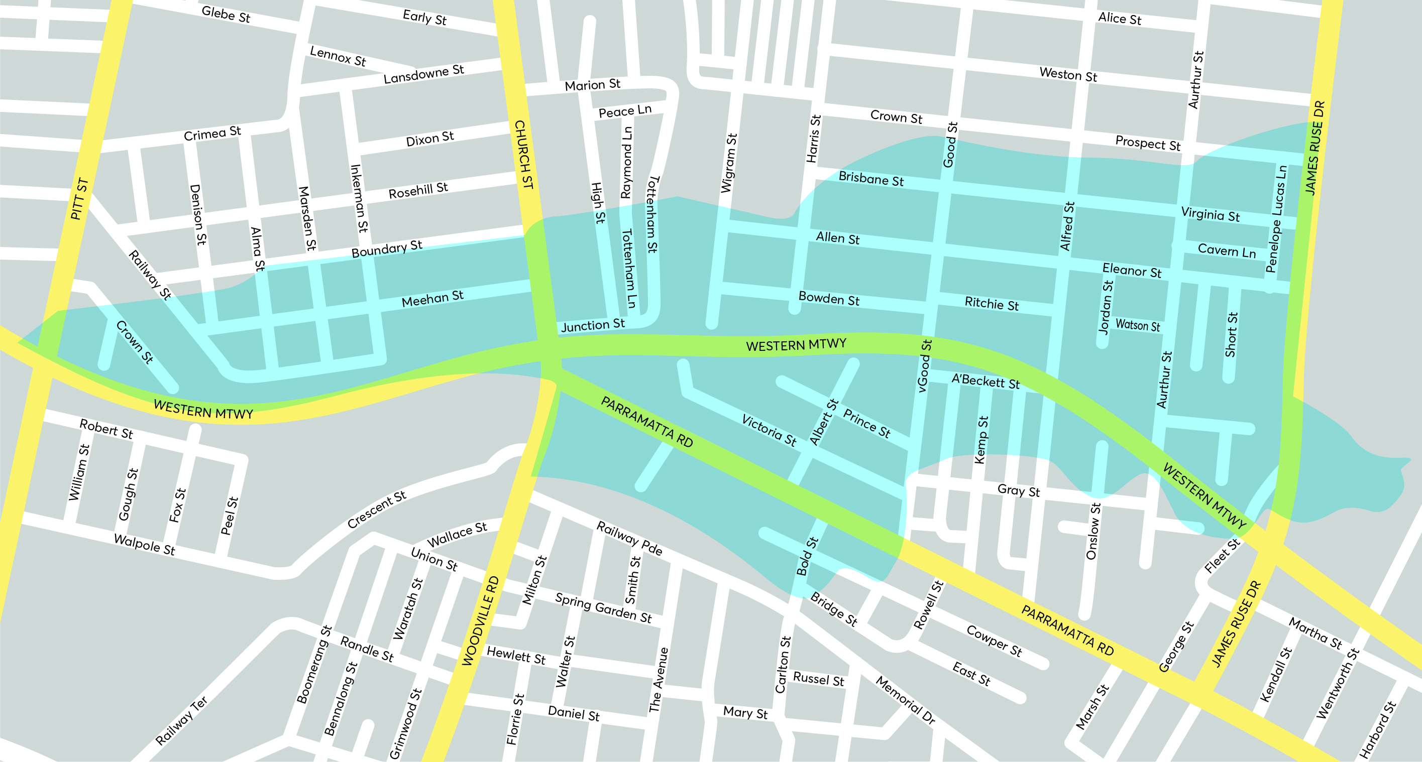
Approximately 1,500 homes in the Granville, Harris Park and Rosehill area have been identified as at risk of flooding in a 1% AEP* flood event.
Most of these properties will only be very rarely affected by flooding. However, there are several that will receive relatively regular, potentially dangerous, flooding.
Knowing where flooding could occur will help City of Parramatta to take appropriate action to reduce or eliminate the risk of flooding to these properties.
*A 1% AEP (Annual Exceedance Probability) is a flood event of a size that has a 1% chance of occurring at a particular location in any given year. This used to be known as a ‘1-in-100-year’ flood, a term which can be misleading. Some parts of Australia have experienced several ‘1-in-100-year’ floods in 10 years or less.
Benefits provided by the new flood study include:
- Providing City of Parramatta Council with a better understanding of flood behaviour across its catchment areas to enable appropriate management of flood risk for existing and future development
- Helping landowners better understand their flood risk so they can be better prepared for flooding
- Helping emergency services (e.g. NSW State Emergency Services - NSW SES - and Police) better understand the impacts on people’s safety when various levels of flooding occur
- Providing FloodSmart Parramatta the information it needs to warn the community of potential flood threats. FloodSmart is the free flood early-warning system provided by City of Parramatta Council.
For most people, there is nothing to do in response to this draft flood study other than to know their flood risk and take appropriate actions for flood planning.
However, if your property is identified as flood-affected and you’re planning on redeveloping your property, you may need to consider the impacts of flood risk during the development process.
There could be requirements including having the floor levels of the development set above the Flood Planning Level (FPL)* to ensures that the impacts of flooding are reduced.
*The FPL considers the depth of flooding which may happen in a number of scenarios deemed as flooding ‘standards’ by the NSW Government.
About 1500 properties in the flood study area have been identified as being flood-affected in a 1% AEP (1-in-100-year) flood. The draft maps in the Resources section will show you if your property seems to be one of these.
Remember, these are draft maps, the final mapping may be somewhat different.
For the Draft A’Becketts Creek Flood Study, the Flood Planning Area (FPA)*, is a term that refers to areas where new developments are likely to be subject to flood-related planning controls to minimise flood risks.
Details of the process used to develop the FPA for the A’Becketts Creek catchment is provided in the Draft Flood Study Report.
The preliminary FPA has been determined as part of the draft flood study. This will be finalised in the next stages of the Flood Risk Management process.
Whilst no immediate action is required by a property owner, should your property be designated flood-affected, and you wish to develop the land in the future, flood-related development controls may be applied to the development consent.
The flood maps which feature as part of this draft flood study highlight which properties are expected to be affected by flooding. Even if a small portion of your property is affected, the whole property area will be classified as being within the Flood Planning Area (FPA)*.
Regardless of flood extent, any development controls are generally applied to a whole property and cannot be split. However, how the development controls are applied to your property will depend on where within the property area the proposed development is located. What type of development is proposed may also influence development consent.
*A Flood Planning Area refers to areas where new developments are likely to be subject to flood-related planning controls to minimise flood risks.
Where property is within the Flood Planning Area*, the need for a property-specific flood study will depend on the type and scale of the proposed development.
Developments which affect the behaviour of floodwaters, and have the potential to negatively impact neighbouring properties, will need to include a flood study. A flood impact assessment will also need to be submitted as part of the Development Application.
The flood study for this area may lead to reduced requirements for a property-specific flood study and flood impact assessment.
*A Flood Planning Area refers to areas where new developments are likely to be subject to flood-related planning controls to minimise flood risks.
The insurance industry already has a good understanding of flood risk across the Parramatta Local Government Area. Individual insurance companies typically identify Flood Prone Land and assess risk through their own flood studies, analysis, and flood mapping exercises.
Whether Council has undertaken a flood study or not, insurance companies set their premiums based on their own information.
For information from the Insurance Council of Australia and other helpful documents please see the Resources section of this page.
Studies show that an actual flood event, rather than a flood notation on a Planning Certificate, is more likely to influence property values.
House prices are largely based on land size, the size and presentation of the house, demand from people wanting to live in the area, and the economic conditions at the time of sale.
However, all landowners with properties at risk of flooding should consider flood insurance and discuss this with their insurance provider.
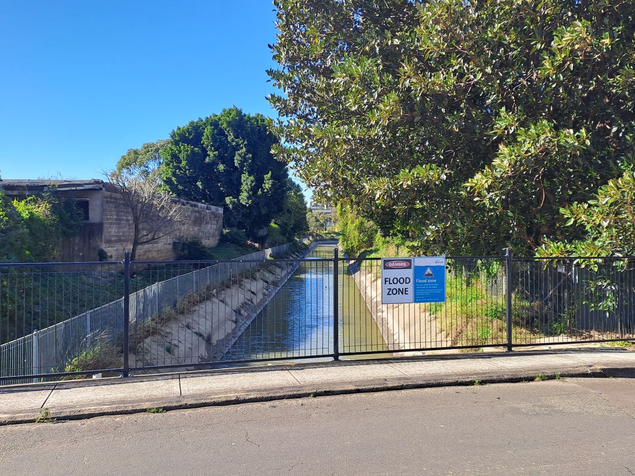
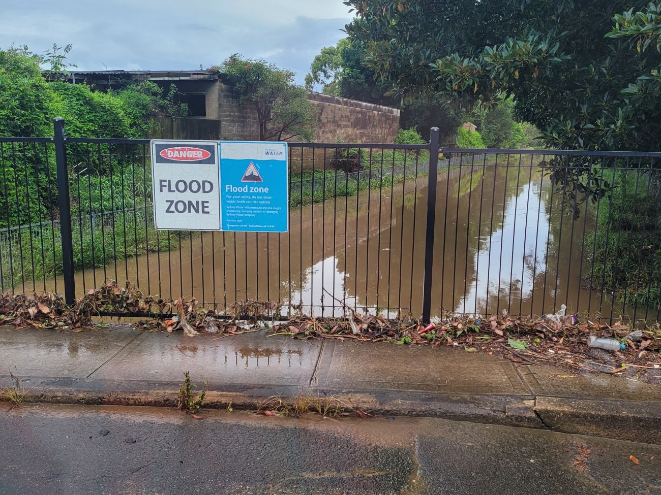
When rain falls, it finds the quickest way to the river. Sometimes, this means going through normally dry land or through gardens and houses or along roads and paths.
If the amount of water is higher than the usual capacity of the route, or something (like fences or walls) blocks one of these routes, it can cause localised flooding.
Localised flooding often happens when a lot of rain falls in a very short amount of time overloading drainage systems. If the ground is already very wet and even more rain falls, this can also cause the stormwater system to become unable to drain water from our roads to the river.
When intense rain exceeds the capacity of local drainage systems, water flows along the easiest path including over or around hilltops or residential properties. This creates potential flood risk for homes despite their relatively elevated location.
A property will be designated as flood-affected based on inundation of the land (i.e. the depth of the water that is expected to pool on your land in a 1% AEP* rather than the floor level of any building on the land).
For Development Applications, the floor level is considered. However, it will likely be at least 0.5m above the 1% AEP level for your property. Any future developments of the property need to address flood risk and planning controls.
*A 1% AEP (Annual Exceedance Probability) is a flood event of a size that has a 1% chance of occurring at a particular location in any given year. This used to be known as a ‘1-in-100-year’ flood, a term which can be misleading. Some parts of Australia have experienced several ‘1-in-100-year’ floods in 10 years or less.
Yes, you can disagree. Flood studies are highly complex and one of the many reasons the draft flood study was placed on public exhibition.
Following the conclusion of public exhibition on Friday 6 February 2026, Council expects to:
- Finalise the A’Becketts Creek Flood Study by incorporating further learnings including residents’ feedback.
- Submit a report and recommended final flood study to Council for endorsement and formal adoption of the study.
- Develop a Flood Risk Management Study and Plan for the A’Becketts Creek catchment. This will include a suite of flood risk management measures.
- Investigate how to implement the outcomes and recommendations of the Flood Risk Management Study and Plan.
Council is currently creating strategic planning documents for several catchments across the Local Government Area. These studies and plans will investigate whether any other flood mitigation works would help to reduce flooding in each of the below catchments:
- Parramatta River Catchment
- A’Becketts Creek Catchment
- Devlins Creek Catchment
- Haslams Creek Catchment.
Council works to reduce the risks of flooding to the community in several ways, including the provision of FloodSmart, a free early-warning service to advise the community about potential flooding.
We also work closely with the SES to safely manage any flooding emergency. For details, please see our webpages at Flooding | City of Parramatta for more information.
Council also has a program for routine inspection and auditing of storm water infrastructure to assess repair and maintenance needs and minimise drainage issues. This also includes street sweeping and stormwater pit cleaning to reduce the amount of litter/leaves entering the drains.
Regular monitoring and cleaning of the stormwater system minimises blockages, improves water flow, and reduces the risk of flooding.
The City of Parramatta is one of the most flash-flood affected areas in the state. We know our flood risk is high and over the years we’ve taken action to manage flooding and support our community – we can’t stop floods happening, but we can work together to help keep everyone safe.
Various teams across Council work on flood modelling and ensure planning and development considers flooding. Other teams design, build, and maintain infrastructure, to manage the risks of flooding and minimise the impact of flood water including via upgrades to our stormwater systems.
In terms of raising awareness around flooding and supporting the community, we’ve worked closely with partners including the NSW SES and Sydney Water to create the award-winning FloodSmart Parramatta service. This free service now monitors 10 areas across the Parramatta LGA providing early flood warnings to our community and advice on preparing for a flood. After heavy rains we’ve seen more than 1,000 new subscribers join this service. Council plans to expand FloodSmart in 2026 to cover more areas.
Council is also part of the Parramatta Local Emergency Management Committee (LEMC). The LEMC involves combat agencies such as the NSW Police, NSW SES, and Fire & Rescue NSW. Together, we support the prevention of emergencies and prepare for and respond to various events including flooding. The LEMC also assists the community in recovery and clean-up operations.
Learn about FloodSmart and watch a short video here: https://www.cityofparramatta.nsw.gov.au/environment/floodsmart-parramatta/free-floodsmart-parramatta-service
In 2020, City of Parramatta secured $144,000 in NSW Government funding for flood investigations in the A’Becketts Creek catchment.
Following public exhibition and refinement of the flood study, a final A’Becketts Creek Flood Study will be released, likely in late-2026.
The next stage of work, following the flood study, is the A’Becketts Creek Flood Risk Management Study and Plan. This project will investigate modifying existing infrastructure, and/or changes to planning codes or other measures to help reduce flooding in our City.
Council will need additional funding for any upgrades to existing infrastructure or to investigate and progress to design and construct stage any new flood management infrastructure.
Should funding for the next stage of the project not be available in Council’s 2026/27 budget, Council will continue to advocate for funding from the NSW Government and the Australian Government.

To download a copy of this map, go to the Resource Library.