Since the pedestrian refuge island was installed in April 2026, Tintern Avenue has effectively operated as a single lane for northbound traffic. Vehicles waiting to turn right onto Pennant Hills Road can block those intending to turn left, resulting in long queues, particularly during school peak times. This turn restriction is proposed to reduce congestion on Tintern Avenue and improve safety for motorists turning onto Pennant Hills Road/Cumberland Highway.
If this restriction is introduced, motorists will not be able to turn right from Tintern Avenue onto Pennant Hills Road.
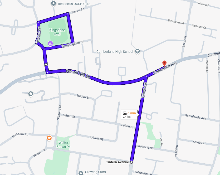
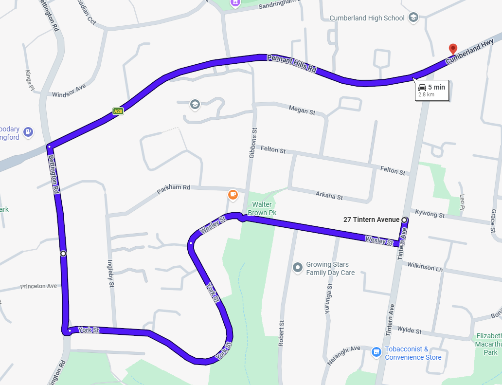
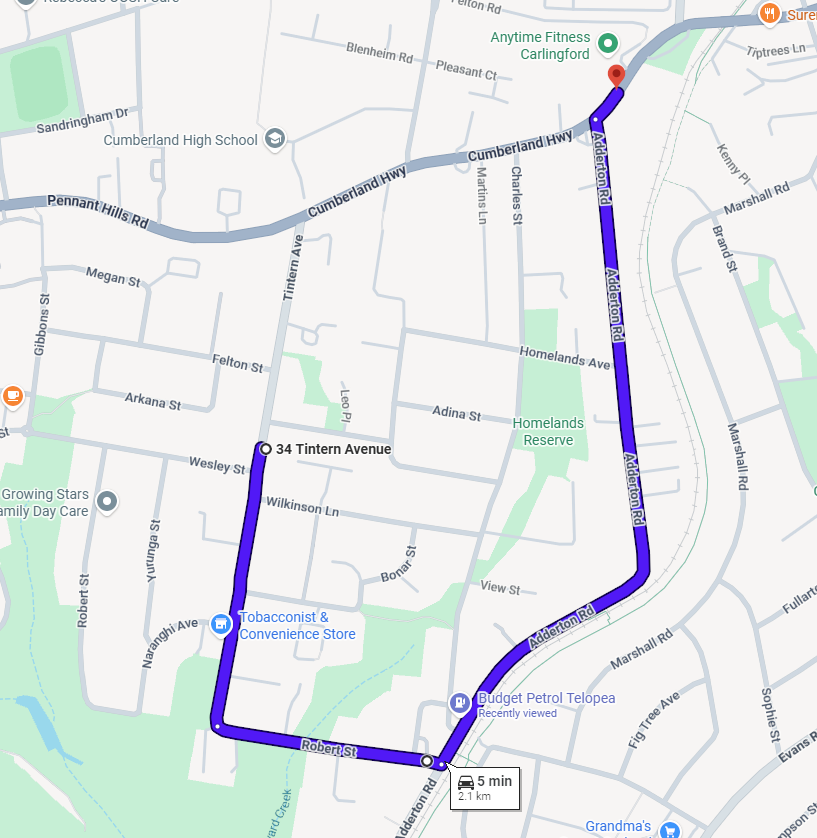
To travel eastbound towards Carlingford, you can use alternative routes such as Westminster Avenue, Bettington Road or Adderton Road to access Pennant Hills Road.
Maps showing these alternative routes are provided below.
Via Westminster Avenue
Via Bettington Road
Via Adderton Road
Community feedback from this consultation will be considered before a decision is made on whether to proceed with the proposed restriction.
If supported, the proposal will be referred to the Parramatta Traffic Forum for consideration. If approved, the restriction is expected to be implemented in September/October 2026.
To stay up to date, FOLLOW this page or make a submission to receive project updates.
A pedestrian refuge island is a small, raised section in the middle of the road that provides a safe place for people to pause while crossing. It divides the crossing into two stages – pedestrians only need to cross one direction of traffic at a time.
The location of the pedestrian refuge island is on Tintern Avenue, Carlingford, just south of Pennant Hills Road, as shown in the plan below.
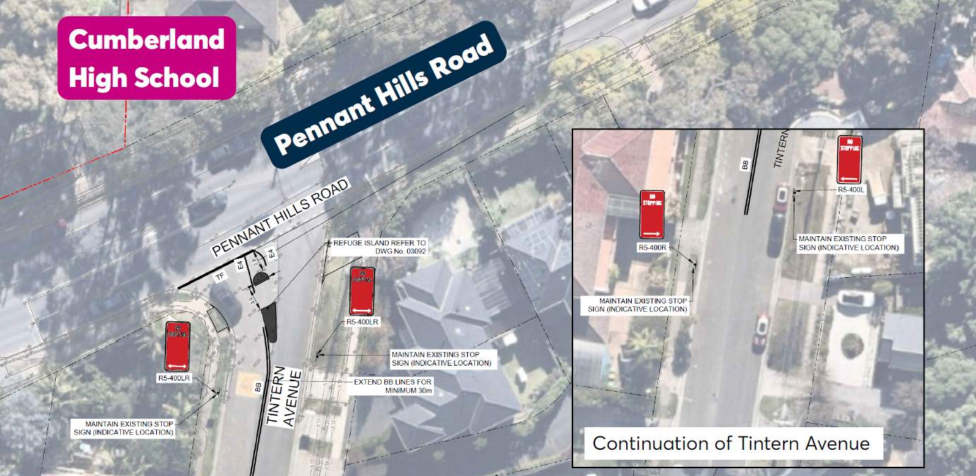
Figure 1: Location for the pedestrian refuge island
Council received 12 responses with eight agreeing, two agreeing to an extent, and two opposing the proposal.
Council heard strong support for pedestrian safety, particularly for school children, alongside some concerns about potential traffic congestion impacts.
In line with the 2025 Authorisation and Delegation for Prescribed Traffic Control Devices and Regulation of Traffic, Council approved the installation of a pedestrian refuge island in Tintern Avenue, Carlingford.
Council planned to closely monitor traffic congestion impacts as the project progresses.
This section of Tintern Avenue, near Cumberland High School and the busy Pennant Hills Road, has been identified as an area with high pedestrian activity from both local residents and the school community. As part of the development conditions for Carlingford West Public School and Cumberland High School, School Infrastructure NSW (SINSW) proposed to install a pedestrian refuge island on Tintern Avenue, just south of Pennant Hills Road, to help improve pedestrian safety.
For the detailed assessment on the proposal, please refer to the Environmental Impact Statement including the Transport Assessment please visit the NSW Planning Portal.
Upgrades to Carlingford West Public School and Cumberland High School | Planning Portal - Department of Planning and Environment
The proposal did not result in any reduction of on-street parking spaces.
The construction work for this pedestrian refuge island took place between March and April 2026.