The project includes restoration of the extensive weedy embankment along the northern foreshore, with removal of weed species and the planting of locally endemic trees and vegetation. Additionally, a boardwalk over water along some of the southern foreshore has been designed to preserve as much high-value riverbank vegetation as possible within design constraints, allowing for minimal disruption to existing ecosystems.
The presence of native flora and fauna on the site has informed the design. The overwater southern boardwalk is a feature that enables retention of mature native trees along the southern embankment and minimal disruption to existing ecosystems. A total of 45 existing trees will be preserved across the site, including the significant Moreton Bay Fig on the northern foreshore near Marsden Street. Up to 54 trees will need to be removed for construction of the bridge and associated infrastructure. However, with the removal of over 3,000 square metres of weed canopy along the northern foreshore, the new tree planting opportunity is significant, with approximately 81 new endemic trees accommodated in the draft concept design across the site.
Further ecological assessments (both aquatic and on-land) will be undertaken to inform the development of the design and subsequent construction phase to ensure that we are minimising impacts and protecting as much natural habitat as possible.
No, less than half of the total foreshore within the project area will be stabilised with walls and balustrades. Hard edges, such as revetment walls, are only used at key locations, particularly where the public foreshore walk passes under existing or proposed new bridges and where the new accessible path leads down the slopes to the river’s edge. The revetment walls are required to stabilise the riverbank, facilitate flood conveyance (movement of flood waters) and create safe and accessible foreshore routes. The majority of the riverbank profile will remain as a graded natural embankment. Council officers have closely considered other alternatives that would retain more natural foreshore however initial site assessments have indicated that revetment walls are the most viable option in locations where hard edges are proposed. Further development will occur in the next design phase, with ecological impacts to be managed and minimised.
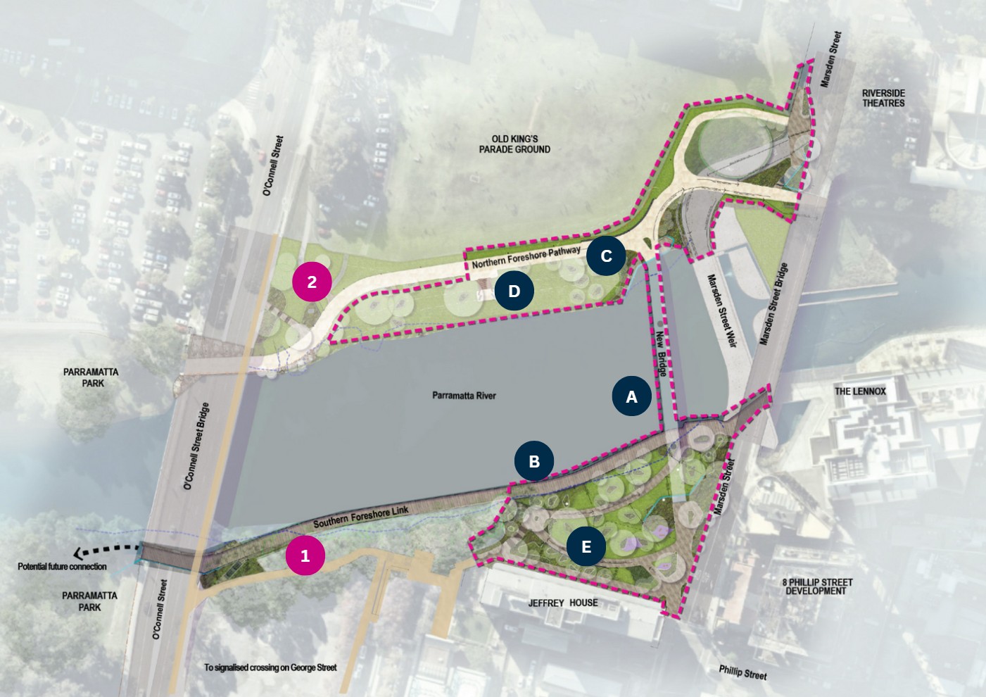
This draft concept design has been developed alongside the design of adjacent projects to ensure safe, seamless, and well-connected foreshore pathways. This coordination aims to create a unified riverfront experience, making it easier for people to move between key destinations along the river. While this project will provide a new accessible link from street to the foreshore on the southside of the river, the Riverside Theatres redevelopment is set to do the same on the northern foreshore. Coordinated upgrades to the existing shared path under the Marsden Street Bridge will connect these two projects, which together will facilitate a new level of interchange and accessibility between the city streets and the river.
A Dharug Cultural Custodian Panel has been established specifically for this project. The Panel guides the expression of Country through the design of public domain and new interpretation elements incorporated into the project. This engagement has and will continue to provide opportunities for Traditional Custodians to share knowledge and cultural insights to inform the design.
Improvements aim to make the northern foreshore path safer, more accessible, and visually appealing for everyone.
The northern foreshore shared path west of the existing Marsden Street Bridge is steep, difficult to access, and has poor visibility. A new, wider, and more accessible pathway is proposed. This will involve re-grading the path and selectively removing and reusing a section of the c1923 heritage wall.
This will ensure a continuous, accessible path between Bernie Banton (Marsden Street) Bridge and Rings (O’Connell Street) Bridge. The project will clear the heavily weed-infested northern foreshore, which currently blocks views of the river and limits passive surveillance. The revitalized riverbank will feature informal grassed areas and a new canopy of native trees, opening up beautiful views of the river.
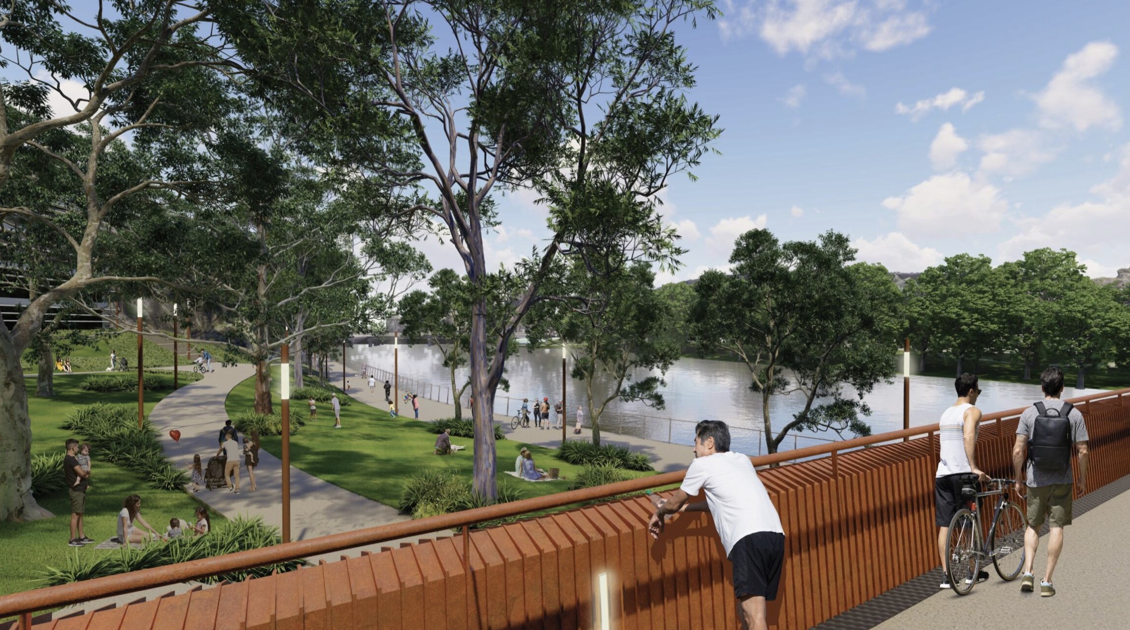
The new southern foreshore link aims to create a seamless and enjoyable experience for pedestrians and cyclists, connecting key areas along the river while preserving the natural beauty of the surroundings.
Currently, there is a missing link in the vision to create a continuous connection along the southern foreshore from the CBD to Parramatta Park. A new southern foreshore link is proposed to provide a safe, accessible, and visually engaging connection along the river’s edge.
The pathway will start from the existing steel pedestrian platform at the Lennox development, passing under the Marsden Street Bridge to connect with the justice precinct foreshore. The pathway will run next to a new revetment wall (engineered river wall) as it passes under the new walking and cycling bridge. West of the bridge, the pathway will transition to an over-water boardwalk. This boardwalk will be designed to sit low against the water, enhancing the green backdrop and minimizing visual impact.
The design aims to enhance public access and create a more inviting and accessible environment along the northern edge of the Justice Precinct.
Public access along the northern edge of the Justice Precinct is currently limited to the top of the riverbank, with entry points from nearby streets. In the proposed design, a new landscape will be created between Jeffrey House and the Parramatta River. This area will feature scattered trees and gently rolling lawns that extend down to the foreshore walkway.
A new pathway will be built to traverse the slope, providing safe and equitable access across the 4.5-metre level change between the street and the foreshore.A stairway located mid-block will offer another link between the upper-level walkway and the foreshore. The graded pathway and the new bridge landing will come together at a new street-level entry plaza next to Marsden Street.
The new bridge aims to enhance connectivity and safety for pedestrians and cyclists while preserving the area's historical and scenic value.
The existing Marsden Street Bridge only has a pedestrian path on the east side and cannot be upgraded to accommodate more pedestrians or cyclists. In response, a new bridge for walking and cycling is proposed. It will have a deck width of 4.5 meters, providing a direct, safe, and flood-free connection between the southern and northern banks of Parramatta River.
The new bridge will be built west of the existing Marsden Street Bridge. This location is chosen to avoid any impact on the heritage-listed weir below and to maintain the scenic views. The bridge will be aligned to frame views to the north of the sandstone façade of the historic Old Kings School within the grounds of Byanami Public School, and to the south, of the Spire of the former St Andrews Church.
The bridge will have a slim, horizontal profile made from weathered steel with integrated balustrades and lighting. The design is simple and elegant, minimizing visual intrusion. It will blend with nearby bridges and allow the heritage landscape to remain the focal point.
The Western River Precinct Connections Project will:
- Improve the capacity and amenity for walking and cycling along the river and make the foreshore more accessible for people of all ages and abilities
- Improve connections between the river, the city and neighbouring destinations, such as the local schools, Commbank Stadium and Riverside Theatres
- Provide additional settings for recreation along the northern and southern foreshore
- Improve safety and inclusivity through universal access designs, upgraded lighting and improved site lines
- Protect and restore ecological zones with strategic tree planting and careful management of existing vegetation
- Strengthen cultural and heritage links to Parramatta Park, Riverside Theatres, and the future Powerhouse Parramatta, enhancing access to key civic and cultural destinations
- Boost urban connectivity between Parramatta City Centre and the wider LGA by supporting the Marsden Street walking and cycling corridor, key infrastructure identified within Council’s Parramatta Bike Plan
The project will advance objectives articulated in Council’s adopted plans and strategies, including:
- Parramatta 2050 with its vision for the City Centre as the Headquarters District – a place to be day or night, attractive business heart, and welcoming to everyone
- The Parramatta River Vision and its ambition for a continuous Parramatta River Valley parkland, as the essential and defining green infrastructure for the City, connecting Parramatta Park to Olympic Park
- The Parramatta Bike Plan and its vision for a fine grained and connected active transport network serving the needs of workers, visitors and residents
- The City River Strategy and its vision for an activated, green and connected river foreshore, integral to the City’s life and identity and setting for major destinations
Heritage considerations are another strong driver for the design given the rich heritage values of the site. The location of the bridge has been selected to protect the values of the heritage weir and highlight the vistas to the significant built heritage in the precinct. The design minimises visual intrusion with a simple and elegant structure, predominantly horizontal that sits comfortably within the family of nearby bridges and allows the heritage landscape setting to predominate.
On the northern foreshore, heritage elements including the remnant brick river stairs and incinerator will be retained. A heritage sandstone retaining wall located on the perimeter of the curtilage to the former Kings School, alongside the access road down to the weir, is significant and reflects several eras of construction and evolution. While the earliest sections of the wall are to be retained in-situ, a 7m-section of wall c1923 will be carefully salvaged and fabric reused to facilitate construction of the accessible walking and cycling route along the northern foreshore. Schoolboy graffiti evident in the stone will be highlighted for interpretation on site.
Flooding is a key consideration in the design. The bridge alignment and structure have been carefully chosen to minimise upstream impacts and ensure resilience. Unlike nearby road bridges the deck of the new walking and cycling bridge is located above water during a 1% event. New landscaping on the northern foreshore will contribute to flood flow while restoring endemic riverbank vegetation. Overall, the project will ensure that the final design results in only minimal flood level increases and only in open space areas already impacted by flooding expected only in open-space areas already that are already affected by flooding.
The project requires environmental assessment under Part 5 of the EP&A Act, with appropriate consultation with agencies. This is to be prepared in the form of a Review of Environmental Factors (REF) once the design is further refined and developed. Initial site investigations are planned to inform the design, including archaeological test excavations, contamination and geotechnical investigations; services investigative surveys to locate key services. An REF will also be prepared to ensure the impacts of these initial site investigations are considered and mitigated.
In addition, applications for approval have been lodged for non-Aboriginal and Aboriginal Heritage with Heritage NSW to enable the site investigations, and a Fisheries permit from the MSW Fisheries will be obtained. Further approvals from these same agencies will be sought subsequently for construction of the project.
Crown Lands must provide landowner’s consent for the works to be conducted in the waterway and the northern foreshore reserve.
At this stage, it is not anticipated that the project will require an Environmental Impact Statement (EIS) to be prepared, and this will be confirmed through the preparation of the REF.
The design includes an overwater southern boardwalk that allows for the retention of mature native trees along the southern embankment.
The presence of native flora and fauna on the site has informed the design. The overwater southern boardwalk is a feature of that enables retention of mature native trees along the southern embankment. A total of 45 existing trees will be preserved across the site, including the significant Moreton Bay Fig on the northern foreshore near Marsden Street. Up to 54 trees will need to be removed for construction of the bridge and associated infrastructure. However, with the removal of over 3,000m2 of weed canopy along the northern foreshore, the new tree planting opportunity is significant, with approximately 81 new endemic trees accommodated in the concept landscape design.
This major project will necessitate closing of the foreshore pathway during at least some of the construction period, with impacts mitigated through staged works, coordination with nearby developments like Riverside Theatres and well signposted alternative routes. Detour routes for pedestrians and cyclists will be prepared and communicated well ahead of the construction phase.
Marsden Street and O’Connell Street will remain open to vehicles, as the existing bridge is retained for traffic. However, construction may require temporary lane closures and temporary site access arrangements.
A new, dedicated walking and cycling bridge will be constructed west of the existing Marsden Street vehicle bridge. This will separate pedestrian and cyclist movement from vehicular traffic, reducing congestion and improving safety and north-south access across the River, supporting Marsden Street as a strategic active transport corridor as confirmed by Council and the NSW Government.
As a result, there is no vehicular reconfiguration: The existing Marsden Street vehicle bridge will remain in use for vehicles, as well as the current pedestrian access on the eastern side.
Improved Street-to-Foreshore Access: new ramps and stairs will better connect Marsden Street to the southern and northern foreshore, enhancing movement and interchange with the Parramatta River Valley corridor.
Monthly trip counts along the city river foreshore measured in 2024 between the Parramatta Quay and Parramatta Park have recorded:
- 55,000 pedestrians and 15,000 cyclists along the northern foreshore
- 45,000 pedestrians and 5,000 cyclists along the southern foreshore
This project is proudly funded by the NSW Government’s Western Sydney Infrastructure Grant program to a total of $26.1m with City of Parramatta Council contributing $2.2m.
The $2 billion Western Sydney Infrastructure Grants Program (formerly known as WestInvest) is funding transformational infrastructure projects across Western Sydney. Funded projects will improve the liveability of communities and support economic recovery, making a real difference to the quality of life in 15 Local Government Areas in the region.
For more information see https://www.nsw.gov.au/grants-and-funding/western-sydney-infrastructure-grants-program