What is a Special Event Parking Scheme (SEPS), and when and where will it apply?
The proposed Special Event Parking Scheme (SEPS) will introduce temporary parking restrictions during major events at Sydney Olympic Park to help manage parking demand on local streets. It is anticipated that there will be approximately 27 days annually (including the duration of the Sydney Easter Show) where events would trigger an activation of the SEPS (SEPS trigger: 60,000+ visitors expected and activation is planned to last 4–12 hours or more).
Currently, street parking in Newington is mostly unrestricted and vehicles can park all day. During an SEPS activation, a 2-hour limit will apply unless a vehicle has a valid permit. Annual permits will be made available for purchase to local residents, their visitors, workers and businesses.
The proposed SEPS area is shown on the interactive map below and divided into seven zones. Permits are valid only in allocated zones. Enter your address to find which zone your property is located within.
Note: Private streets are not included in the scheme.
How will the permits work?
Vehicles with valid permits will be able to park on-street for more than 2-hours in allocated zones during SEPS-activated periods. Four permit types are proposed below, with fees based on the 2026/27 Fees and Charges (fees are reviewed annually).
| Permit type | Format | Annual limit | Propose per permit fee |
| Resident permit | Electronic permit (no display required once purchased) | 2 permits per household | $19.30 ($10.30 for pensioners, students and unemployed persons) |
| Visitor permit | Physical scratch permit (sold in a booklet of 10, must be displayed on vehicle, and is valid for one day only)^ ^Council may provide an electronic version in future | 30 permits per household | $50 per booklet (10 permits) $150 for three booklets |
| Business permit (ex. home businesses) | Electronic permit (no display required once purchased) | 2 permits per business | $56.70 |
| School permit | Electronic permit (no display required once purchased) | Based on No. of teachers and staff | $56.70 |
---
How will I know when the SEPS is activated?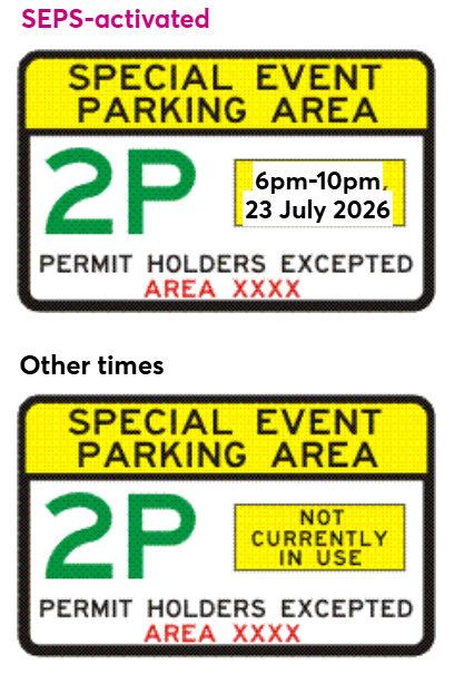
If the scheme goes ahead, entry signs will be installed at six key entry points to the SEPS area, including locations such as:
- Avenue of Oceania (at Avenue of Europe), Newington
- Avenue of Oceania (west of Hill Road or west of Louise Sauvage Pathway), Newington
- Wing Parade (West of Hill Road or west of Louise Sauvage Pathway), Newington
- Beaconsfield Street, Silverwater
- Barker Avenue, Silverwater
- Wetherill Street North, Silverwater
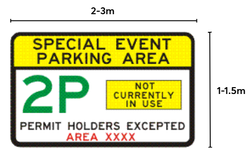
When the SEPS is activated, time plates will be updated to show the activation period. Activations are expected to last between 4 and 12 hours, depending on the event. You will be able to check upcoming SEPS activation dates on a dedicated Council webpage, which will be updated approximately three months in advance.
How many new on-street signs will be needed to establish the proposed SEPS?
Around 467 new on-street signs will be installed across the area to inform drivers of SEPS conditions and support enforcement in line with NSW Road Rules. Repeater signs will be placed at least every 200 metres and on every street or street block longer than 30 metres. Additional signs will be installed after major features such as roundabouts, intersections with collector roads, or where other parking controls apply.